Our Projects
We are committed to provide valuable social services to the community in Sri Lanka
We are committed to provide valuable social services to the community in Sri Lanka
The Community Legal Assistance Center is incorporated to facilitate the charitable services in Sri Lanka which is incorporated and registered under G A 683 in 05th May 2011. We have been lunched several social services in Sri Lanka for last 6 years. initially we have carried out a services to provide the service of attorneys-at-law and any other legal experts, free of charge, to any person or persons those who cannot afford to pay for such services and help to protect the rights established by the constitution of Sri Lanka and any other statute enforced in Sri Lanka.
In addition to that we have following additional objectives to provided better services to the community of Sri Lanka.
- Contribute for all type of social services in Sri Lanka.
- Contribute for all type of Donations and rehabilitation projects.
- Contribute for all type of medical and health services.
- Contribute for damages occurred due to all type of natural disasters.
- Contribute for educational / sports and sport activity development projects (Including equipment).
- Contribute for road development and infrastructure development as a social service.
Major Natural Disasters in Sri Lanka
In Sri Lanka, floods, landslides, cyclones, droughts, wind storms, coastal erosion, tsunami, sea surge, and sea level rise are the main natural hazards that generate disasters. These natural disasters have caused loss of life, and enormous damage and destruction to property. In addition to these natural disasters, the country also incurs heavy losses on account of manmade disasters such as deforestation, indiscriminate coral, sand and gem mining, and industrial hazards besides ethnic conflicts and occasional political violence in the recent past.
Flood
 Floods are more of common occurrence in Sri Lanka than the other natural disasters. There are 103 river basins of which about 10 rivers are considered as major. Among these major rivers Kelani, Gin, Kalu, Nilwala and Mahaweli are vulnerable to floods. The increase in population and subsequent need for land have forced more and more people to live and work in these vulnerable areas, thereby intensifying the risk to life and property in the event of major floods. Heavy rainfall and runoff the large volume of water from the catchment areas of rivers, deforestation, improper land use and the absence of scientific soil conservation practices could be identified as the major factors for floods in Sri Lanka. Urbanization with the insufficient infrastructure facilities such as drainage system triggers the urban flash floods together with global phenomena like climate change, which increased rainfall intensities. The districts of Kegalle, Ratnapura, Kalutara, Colombo, Gampaha and Galle are subject to floods on account of Southwest monsoon rains, while Ampara, Trincomalee, Badulla, Polonnaruwa, Batticaloa, Matale and Monaragala suffer from the Northeast rains.
 (image: Districts Vulnerable to Flood Hazard)
Quick Links
-
Major Natural Disasters in Sri Lanka -
Disaster Profile of Sri Lanka -
Spatial Distribution of Disasters -
Our New Project
In Sri Lanka, floods, landslides, cyclones, droughts, wind storms, coastal erosion, tsunami, sea surge, and sea level rise are the main natural hazards that generate disasters. These natural disasters have caused loss of life, and enormous damage and destruction to property. In addition to these natural disasters, the country also incurs heavy losses on account of manmade disasters such as deforestation, indiscriminate coral, sand and gem mining, and industrial hazards besides ethnic conflicts and occasional political violence in the recent past.
Major floods are associated with the two monsoon seasons. Heavy rainfall in the Eastern and South-Western slopes is a principal cause of the flood risk. In addition, the drainage and topography of certain districts and land use patterns are also significant factors. The Western slopes receive rainfall in both Maha (September to January) and Yala (May-August) seasons, and is prone to flooding in these periods. The Eastern slopes of the country receive most of the rainfall during the Maha season (September to January). This is also the cyclone and storm season that can bring heavy rainfall in short time periods. Thus the two regions show distinct flood seasonality. The District of Vavuniya shows a higher flood probability due to cyclonic storms. Even though the annual rainfall is lower than the Western highlands, Vavuniya and Mullaitivu in the North have recorded the highest rainfall intensities in the island.
Landslide
 Excessive rainfall, typical landform and geology, deforestation and unplanned land use practices combine to create landslide hazard especially during the last two decades in the mountain slopes of the Central and South Western regions of the Island. Landslides like any other natural disaster are a concern to us as they threaten the life and property of the people in the hill slopes.
(image: Districts Vulnerable to Landslide Hazard)
The districts of Badulla, Nuwara Eliya, Ratnapura, , Kandy and Matale are most prone to landslides. The highest risk is in the Kegalle District followed by Ratnapura and Nuwara Eliya Districts. Even within these Districts, there is spatial variability at Divisional Secretariat level. Changes in land use including cultivation of tobacco on steep slopes, land clearing in the hills, blocking of drainage paths, and the impact of the large reservoir construction may be the cause of the increase.
Drought
 Drought is the most significant hazard in Sri Lanka in terms of people affected and relief provided. Drought occurs in the south-eastern, north central and north-western areas of Sri Lanka due to low rainfall during monsoons. In some areas, consecutive years of drought had lasting impact on livelihood options .The prevalence of drought maybe surprising given that Sri Lanka receives on average 1,800mm of rainfall annually. However, it is distributed unevenly. A large part of the island is drought-prone from February to April and on to September if the subsidiary rainy season from May to June is dry. There is a stronger tendency to drought in the South-Eastern district of Hambantota and the North-Western region of the Mannar and Puttalam. The drought tendency is markedly less in the South-West corner of Sri Lanka where there is heavy rainfall. Main causes of drought are low rainfall, deforestation, improper land use and unplanned cultivation.
Although droughts cannot be classified as sudden disasters,they do cause hardship and financial loss mostly to farmers.(image: Districts Vulnerable to Drought Hazard)
Earthquake
Sri Lanka is not located near any of the main plate boundaries that are prone to earthquakes. Indeed, it was head on a plate that extended from Australia to India. In the last decades, however this plate is beginning to rotate on account of accumulation of runoff from the Himalayas in the Bay of Bengal and other reasons leading to a fissure between the "Australian" and "Indian" plates. Some scientists believe that this is leading to a new plate boundary across the Southern Indian Ocean. This boundary is still approximately a 1000km from the south of Sri Lanka. Yet, these shifts have to be more carefully monitored and seismological studies need to be carefully followed. The Geological Survey and Mining Bureau is the goverment agency entrusted with seismological studies and it hosts a seismic station at Pallekelle in the Kandy District which is part of the global network of seismographs. Further research is needed to elucidate the consequences of compressions set up in the India plate and the impact of the recent earthquake on the regional hazards and also more precisely estimate the probabilities of the risk of earthquakes closer to Sri Lanka.
Tsunami
While Sri Lanka is far away from the plate boundaries, yet it is close enough to the highly active seismic zone near Sumatra and other regions to its South-East that earthquakes generated in this region may lead to a Tsunami Hazard in Sri Lanka. Tsunamis are rarer in the Indian Ocean as the seismic activity is much less than in the Pacific. Tsunami's are extremely infrequent - the last major volcanic explosion in the Indonesian island of Krakatau led to a Tsunami in Sri Lanka in August of 1883. The wave heights that resulted however were much smaller than the 2004 Tsunami. While earthquakes could not be predicted in advance, once the earthquake is detected it is possible to about an hour's notice of a potential Tsunami for every 500 km distance from the epicenter. Such a system of warnings is in place across the Pacific Ocean. Once the large amount of pent-up energy in the compression zones of the plate boundaries have been released, it takes another buildup of energy for another event of similar magnitude. Thus another Tsunami at the same location is unlikely in the short-term from the same epicenter. In the future, Indian Ocean littoral regions should generate and pay attention to earthquake and tsunami warnings. Tsunamis are likely to have a more modest impact on the coastal zone from Killinochchi to Puttalam.
Coastal Erosion
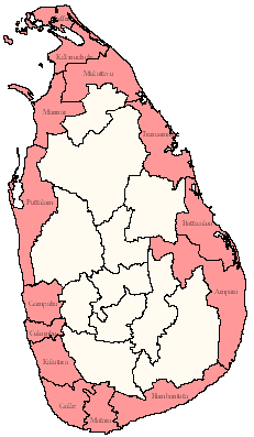 Sri Lanka has a coastline of 1585 km. More than half of her 19.5 million population live in villages, towns and cities of the coastal districts. The economic importance of the coastal areas has increased further with the rapid urbanization, the development of commercial harbors (Colombo, Galle and Trincomalee). Fishing harbors and anchorages, main lines of communication (road and rail) recreational facilities and tourism. It has been estimated that over 50- 55 percent of the shoreline is subjected to or threatened by coastal erosion. The effects of coastal erosion are largely felt in the west, south-west, and southern coastal belt. Coastal erosion severely affects infrastructure facilities such as the railway, road system and disturbs economic activities along the coast such as fishing, recreational and other coast-related activities.
More over sea serge is also occur in within the Sri Lankan territory. (image: Districts Vulnerable to Coastal Hazard)
Sea Level Rise
Current sea level rise has occurred at a mean rate of 1.8 mm per year for the past century and more recently, during the satellite altimetry era of sea level measurement, at rates in the range of 2.9-3.4 ± 0.4-0.6 mm per year from 1993-2010. Sri Lanka's marine ecosystem will be highly affected due to sea level rise. Apart from that increase of soil salinity and the deterioration of water quality is also another few impacts due to sea level rise.
Cyclone
 Sri Lanka has been affected mostly by cyclone activity occurring in the Bay of Bengal. The Eastern, Northern and North Central regions are the cyclone prone areas of Sri Lanka. Although cyclones do not occur frequently in Sri Lanka, these are not totally outside the range of disasters. The records show that cyclones have affected the Eastern, Northern and North Central Provinces.
There have been four severe cyclones during the last 100 years as well as a number of severe and moderate storms. The cyclones that pass through Sri Lanka originate from the Bay of Bengal during the North-East monsoon which develops in November and lasts a few months. Cyclone incidence shows a strong seasonality and 80% of all cyclones and storms occur in November and December. Incidences of cyclones that pass through Sri Lanka in other seasons is rare due to geography and the regional climatology.
Disaster Profile of Sri Lanka
Hazard profile of Sri Lanka has summarised the major hazards experienced in Sri Lanka. Disaster profile is mainly based on the hazard profile and all the details are based on the historical records obtained from Desinventra database.
Disaster Topology
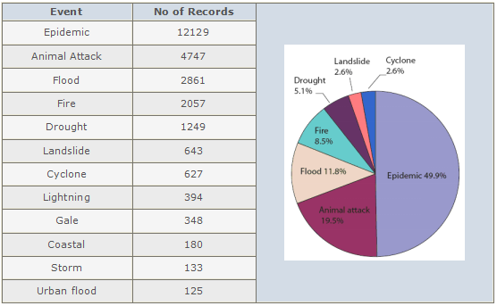
The table above describes the number of data cards (reports) that have been entered for each hazard type from 1974-2007. The seven most frequently reported disaster events represented in the pie chart above include: epidemics, animal attacks, floods, fire, droughts, landslides and cyclones. The hazard that has been reported to occur most frequently in the country is epidemic, with a total of 12,129 data cards reported between 1974-2007; followed by animal attack with 4,747 data cards reported; flood with 2,861 data cards; fire with 2,057 data cards; drought with 1,249 data cards; landslides with 643 data cards; and finally cyclone with a total number of 627 data cards reported.
The table below depicts the total number of deaths that have resulted from the occurrence of the 12 most frequently occurring hazards from 1974-2007. Looking at the pie chart below, while epidemics have occurred most frequently, it was the tsunami that claimed the largest number of lives totaling 39,331 deaths, followed by cyclones (2,344 lives), epidemics (1,384 lives), animal attacks (1,055 lives), landslide (870 lives), floods (498 lives) and lightning (437 lives).
The table above depicts the damage and destruction caused to housing from the occurrence of the 12 most frequently occurring hazards from 1974-2006. The pie chart shows that floods have caused the greatest damage and destruction to housing, followed by cyclones, tsunami, gale, landslides, animal attacks and storms. Between 1974-2007 floods have destroyed a total of 49,891 houses, cyclones 65,756 houses, tsunami 44,250 houses, gale 58,210 houses, landslides 2,029 houses, animal attacks 1,283 houses and storms 332 houses.
The table above depicts the damage destruction caused to crops and paddy from the occurrence of the 12 most frequently occurring hazards from 1974-2007. The pie chart shows that droughts account for the largest proportion of crop losses amounting to 530,685 hectares followed by floods, amounting to 170,159 hectares, animal attacks amounting to 24,590 hectares, cyclones amounting to 4,409, forest fires amounting to 1,128 hectares, storms amounting to 1,000 hectares and finally gale amounting to 440 hectares.
For the period 1974-2007, the largest proportion of emergency assistance has been spent on droughts, followed by floods, cyclones, the tsunami, epidemics, coastal erosion and landslides. Emergency supplies worth Rs. 1,110,434,179 have been spent on droughts, Rs. 636,614,913 on floods, Rs. 223,520,392 on cyclones, Rs. 31,180,200 on the tsunami, Rs. 24,647,000 on epidemics, Rs. 18,620,429 on coastal erosion and finally Rs. 15,350,969 on landslides.
Temporal Analysis of Disasters
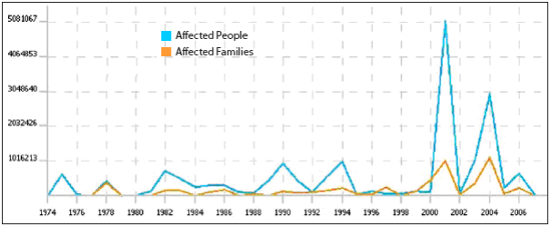
The bar graph above demonstrates the overall trend of hazard occurrence capturing all 25 hazard types included in the database. The greatest number of disaster records to have been captured in the system were in 1976 (2,945 data cards), 1978 (2,302 data cards), and 1974 (1,712 data cards)4, with the lowest number captured in 1979 (110 data cards) and 2007 (57 data cards). The average number of disaster records in Sri Lanka from 1974-1984 was 1,107, between 1985 and 1995, was 441 and between 1996 and 2006 was 1,023.
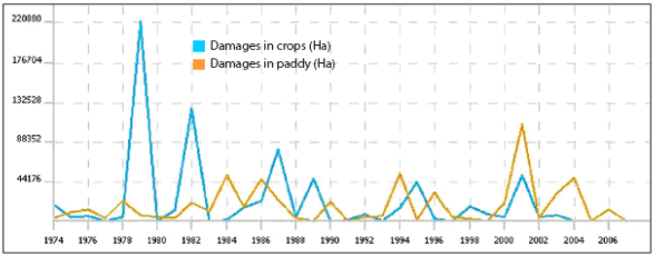
The greatest destruction to housing from various disasters occurred in 2000, 2004 and 2003, during which 123,924; 44,483 and 14,866 houses were decoyed respectively, attributed mainly to the cyclones that occurred in 2000 and 2001, the floods of 2000 and the tsunami of 2004. The largest numbers of families were affected by various disasters in 2001 and 2004, mainly as a result of major droughts and the tsunami. 5,081,067 people were affected in 2001 and 2,970,985in 2004. The greatest damage to crops occurred in 1979 (220,880 hectares), 1982 (126,280 hectares), and 1987 (80,417 hectares) and the greatest damage to paddy occurred in 2001 (108,448 hectares) resulting from the occurrence of drought and floods during those years.
Spatial Distribution of Disasters
Distribution of Events for All Hazard Types
Figure 1 shows the distribution of hazards across Districts and Divisions, and Figure.2, Figure 3, Figure 4, and Figure 5, show the numbers of people affected, people killed, damage and destruction to housing and crop losses for multiple hazards in different Districts and Divisions.
The maps above show that Colombo is the most multi-hazard prone District (as indicated by the largest number of data cards entered)5, followed by Kurunegala, Anuradhapura, Kalutara, Ratnapura, Matale, Kandy, Badulla, Puttalam and Hambantota. The most disaster prone DS Divisions in Kurunegala include: Galgamuwa, Kurunegala, Polpithigama, Ambanpola and Ibbagamuwa. The most disaster prone DS Divisions in Anuradhapura include: Kekirawa, Horowpothana, Palagala, Palugaswewa and Medawachchiya. The most disaster prone DS Divisions in Kalutara include: Kalutara, Panadura, Mathugama. Bulathsinhala and Beruwala. The most affected DS Divisions in Ratnapura include: Ratnapura, Embilipitiya, Balangoda, Weligepola and Kahawatta. Finally the most disaster prone DS divisions in Matale include: Dambulla, Wilgamuwa, Matale, Naula, and Laggala-Pallegama.

(Figure 1 Distribution of Hazards across Districts and Divisions)
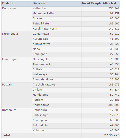
The largest number of people (3,329,806) has been affected by various hazard events in Ratnapura, followed by 2,036,295 people in Batticaloa, 1,638,509 in Monaragala, 1,625,443 people in Puttalam, 1,410,425 in Kurunegala, 1,072,272 in Ampara, 1,041,128 in Anuradhapura, 850,212 in Hambantota, 809,017 in Kalutara, and 635,674 in Matara. The table below shows the DS Divisions from five Districts mentioned above, in which the greatest numbers of people and families have been affected.
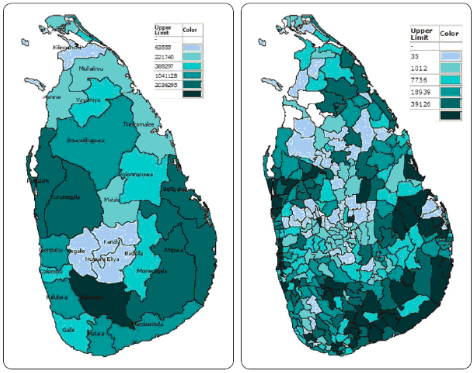
(Figure 2 Distribution No of People & Families Affected across Districts & Divisions)
Distribution of Human Lives Losses
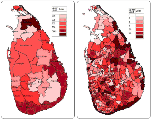
(Figure 3 Distributions of Human Lives Losses across Districts and Divisions)
The largest number of people (26,346) have been killed in Mullaitivu, followed by Ampara, (4,321), Batticaloa, (3,820) Hambantota, (2,638), Galle (1,639), Matara, (1,518), Trincomalee (994) Jaffna, (993), Ratnapura, (484), and Kegalle, (392). The table below shows the DS Divisions in Ampara, Batticaloa, Hambantota and Galle districts where largest numbers of deaths have occurred.
DS Divisions in Selected Districts where the Largest Numbers of Lives Lost

Distribution of Damage Houses
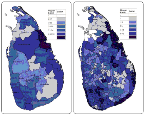
(Figure 4 Distributions of Damage Houses across Districts and Divisions)
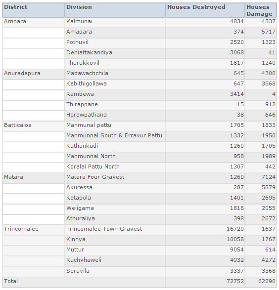
The greatest destruction to housing has occurred in Trincomalee with 106,672 houses destroyed, followed by Ampara (23,378), Batticaloa (22,516), Anuradhapura (12,788), Kalutara, (8,606), Matara (8,317), Galle (7,104), Polonnaruwa (6,251), Ratnapura (4,571) and finally Mullaitivu (4,565). The table below shows the DS Divisions in Trincomalee, Anuradhapura, Ampara, Batticaloa and Matara in which the largest number houses have been damaged and destroyed
Distribution of Crops and Paddy Losses
Kurunegala has suffered the greatest crop losses (141,400 hectares of crops), followed by Matale (123,092 hectares of crops), Polonnaruwa (71,220 hectares of crops), Matara, (57,119 hectares of crops), Kalutara (57,052 hectares of crops), Moneragala (41,760 hectares of crops), Badulla (41,374 hectares of crops), Ampara (23,698 hectares of crops), Puttalam (6,957 hectares of crops), Anuradhapura (9,736 hectares of crops), Ratnapura (22,454 hectares of crops) and finally Kegalle (21,904 hectares of crops). The table below shows that DS Divisions that have been most affected by paddy and crop losses in five Districts, that have been affected the most.

(Figure 5 Distributions of Crop & Paddy Losses across Districts and Divisions)

Most Vulnerable Districts on Multi Hazards

(Figure 6 Vulnerable Districts)
The most multi-hazard prone District (as indicated by the largest number of data cards entered), is Colombo followed by Kurunegala, Anuradhapura, Kalutara, and Ratnapura. However the largest number of people was affected in Ratnapura, Batticaloa, Monaragala, Puttalam, and Kurunegala, and the greatest destruction to housing occurred in Trincomalee, Ampara, Batticaloa, Anuradhapura, and Kalutara.
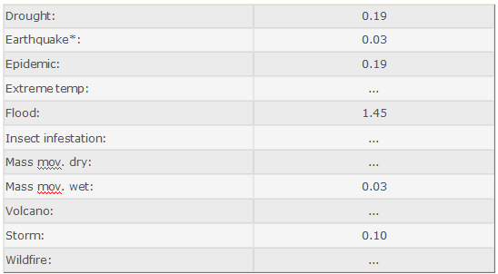
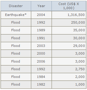
Sri Lankadisaster profile indicates that flood is a most reported disaster and causes economic damages to the island. In average around 1200 people loss their life to the natural disasters in the country. The Indian ocean Tsunami (Earthquake*) occurred on 26th December 2004 had a severe impact on Sri Lanka causing 35,399 deaths, which is more than 95% of the total deaths caused due to Natural Disaster in three decades. Huge economic loss was also caused by the Tsunami.
Natural Disasters from 1980 - 2010
Overview

Natural Disaster Occurrence Reported

Average-Disaster per Year
Top 10 Natural Disasters Reported
Affected People
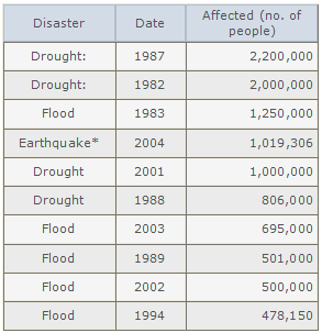
Killed People

Economic Damages
Our New Project
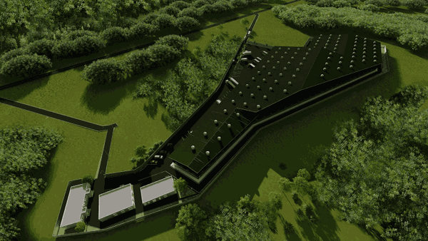
According to the current proposal of our organization we have lunched to new project to start a disaster management center in Ekala, Ja-Ela in Sri Lanka
According to the current proposal of our organization we have lunched to new project to start a disaster management center in Ekala, Ja-Ela in Sri Lanka
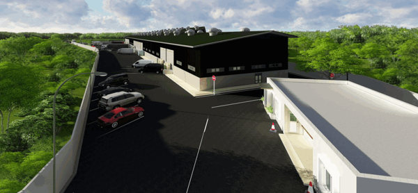
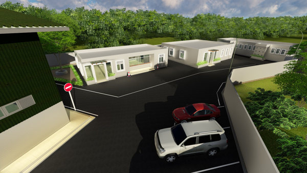
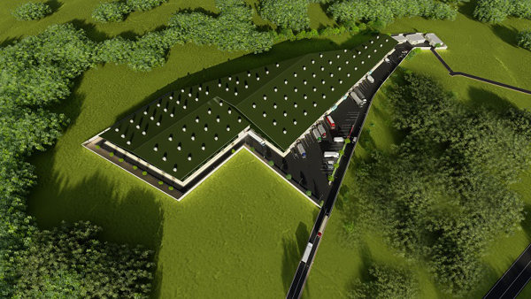
The disaster management center buliding complex - Ekala (450,000sqft)
We have started building of new massive warehouse and building complex on 1st March 2017 at ekala. Ja-Ela (Sri Lanka) located in distance away 8Km from Katunayaka international Airport and 15Km away from Colombo Port and 2Km from new Negambo-Matara high-way. We are planning complete the project by 31st December 2017. With our new objectives for maximize the social services to the public, we are planning build up the warehouse with latest technology and fully equipped in order to handle entire logistic operation process according to requirement of facilitate the hi slandered social service. The total building and aria allocation plan as follows;
- Massive fully equipped warehouse complex to facilitate the store requirement of equipment and materials related to any type of social service
- Building arrangements to provide the accommodation facility for related professionals and the staff who is providing the service for the social services
- Office Complex
- Helicopter pads
- Vehicle Yard
- Heavy Vehicle and machinery yard
- Laundry facilities
- Communication Center
- Medical Center
- Accommodation center for peoples
- Computer Lab / Data Processing unit
- Conference Hall
- Educational Center
Location - Ekala Ja-Ela
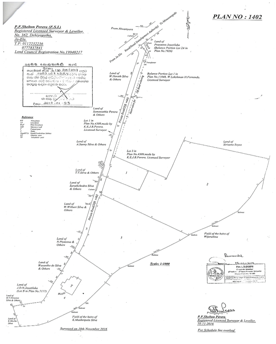
(Survey Plan No:1402 - New massive warehouse and building complex)



Project Details
The construction of the warehouse and the other required building can be introduced as the initial stage of the project. We required the fully modern and equipped massive warehouse to store all type of disaster management equipment and material. The estimated cost for the Warehouse building with Equipment -2.6 Bn.
The Warehouse building should be mainly arranged to facilitate following items;
Building Materials
- Cement
- Building Blocks
- Metal
- Iron Bars
- Paint
- Roofing Products
- Wooden Bars
- Glass
- Electrical Item
- Floor Tiles
- Sands
Disaster management Equipment
- Fiber glass boats / Air Boats
- Boat engines
- Life Saving Jackets and Equipment
- Camping tents
- Water Bottles
- Can Foods /Other food items
- Medicine/Drugs
- Mattress /Pillows
- Folding Beds
- Generators
- Other Electrical equipment and Accessories
- Other sanitary were equipment and material
- Fire Fighting Equipment
- Wood cutters
- Mining Equipment
- Warning system equipment
- Hi-Lift Jacks
- Communication Equipment
- Gas Cookers
- LP Gas Cans
Other Equipment and Machinery
- Off-Road (4x4) Vehicles = 10 Vehicles
- Trucks = 25 Vehicles
- Excavator = 6 Nos
- Crane = 4 Nos
- Tractors = 20 Nos
- Water Bowser = 15 Nos
- Motor Bikes = 25 Nos
- JCB Machines = 12 Nos
- Large Generators = 10 Nos
- Fire Machine = 2 Nos
- Fire Machine = 2 Nos
Washing Plant
- Large washing Machine = 5Nos
- Washing plant equipment
- Building
- Building arrangements to provide the accommodation facility for related professionals and the staff who is providing the service for the social services.
Assets to be required- Furniture and Fittings
- AC Units = 50


